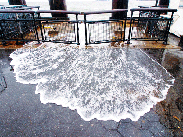
Battery Park, which was flooded after Huricane Sandy Oct. 29, would get added protections under a recommendation by NY Rising’s Southern Manhattan committee.
BY SAM SPOKONY | Downtown community leaders are calling for nearly $5 million in federal funding to begin studies or construction of flood barriers around Lower Manhattan, as part of their post-Hurricane Sandy resiliency plan that was created for the state’s NY Rising Community Reconstruction Program.
The 194-page Lower Manhattan plan which also calls for tens of millions of dollars in funding for other storm resiliency and preparedness measures — was completed at the end of March, following a series of planning committee and public meetings, and was presented to Governor Andrew Cuomo and other state officials on April 23, alongside those from dozens of other communities across the state. It is now also publicly available through the NY Rising website (stormrecovery.ny.gov/nyrcr/final-plans).
The NY Rising program was designed to provide Sandy-affected communities around the state with up to $25 million for projects outlined in their local plans, although the state still has to decide which projects it will fund. And although NY Rising is administered by the state, the funding will come from the U.S. Department of Housing and Urban Development — specifically, the Department’s Community Development Block Grant – Disaster Recovery program.
The Lower Manhattan plan targets two specific sites — Battery Park and the southernmost edge of Hudson River Park — for potential barriers, while also proposing flood barrier studies of both the East and West Sides of Manhattan all the way up to 14th St.
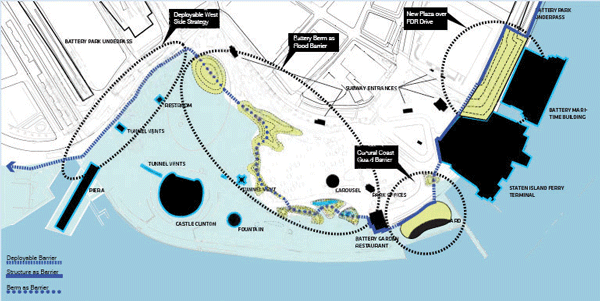
This Battery Park image details a $2 million funding request to construct flood barriers. The
barriers, a mix of raised landmasses and deployable walls, would run along most of the area highlighted by the largest oval, second from the left. (The circular green area at the top left of that oval is a landmass already under construction by the city’s Parks Department.) The far left oval highlights another aspect of the NY Rising plan, which calls for a study of potential barriers along Battery Place.
Specifically, the plan calls for $2 million to construct a combination of five- to six-foot-high berms (sloping landmasses) and four-foot-high deployable walls through the Battery Lawn and Bosque, spanning a total of around 700 feet in length. Those barriers — which, if funded, would be built by the city’s Parks Department ― would lie next to a smaller series of berms that are already under construction by Parks, and which will be completed within months, according to Hope Cohen, chief administration and finance officer for the Battery Conservancy, which had already been planning these measures well before the NY Rising plan was conceived.
The funding sought for those berms and deployable walls would also be just a first step in the Conservancy’s more comprehensive, long-term barrier plan that could eventually stretching across the west side of the park, into Battery Park City, and farther east, to the nearby U.S. Coast Guard facilities and the Whitehall Ferry Terminal.
“We’re excited about being at the forefront of this kind of resiliency planning,” said Cohen, who was on the planning committee that created the NY Rising plan for Lower Manhattan. “[Battery Park] was seen worldwide as a waterfront park that was hit really hard by [Hurricane Sandy’s] strom surge, so ever since we’ve really been working hard to prepare for the next one, to make sure that we’re now seen as a park that’s really resilient to those surges.”
Tying into that overall vision, the NY Rising plan also calls for $750,000 to fund a study of flood barriers near the bottom of Hudson River Park, around Harrison St., which would protect lower West St. — particularly Battery Park City and the area around the World Trade Center — from storm surges. The study would also focus on the potential for barriers just below West St., along Battery Place (which would even more directly tie into the construction of similar barriers within Battery Park). The plan estimates that eventual construction of flood barriers at those locations would likely cost around $8.4 million.
The third element of the plan’s flood barrier-related focus calls for $2 million to fund another study of possible barriers throughout both of Lower Manhattan’s coastal areas — from Harrison St. to W. 14th St. on the West Side, and from Montgomery St. to E. 14th St. on the East Side. That study would specifically review and tie into existing proposals, such as the East River Blueway plan that was introduced by then-Manhattan Borough President Scott Stringer last year.
The 17-member planning committee that created the Lower Manhattan plan — after numerous public meetings attended by residents and other local stakeholders — was co-chaired by Catherine McVay Hughes, chairperson of Community Board 1, and Daniel Ackerman, chief of staff for the Downtown Alliance. The committee also included David Gruber and Gigi Li, who respectively lead Community Boards 2 and 3.
Hughes pointed out that overlapping and ongoing efforts Downtown, like those of the Battery Conservancy and the various landscape architects involved with the East River Blueway Plan, played a strong role in shaping the final plan.
“One of the important purposes of this process was really to leverage some initial funding for these larger projects, to start bringing that money in and putting it to work,” she told Downtown Express.
The NY Rising plan also calls for up to $7.6 million to create a network of community resource and recovery centers across Lower Manhattan, which in emergency situations would provide residents faster access to food and water — as well as electrical power and cell phone charging stations — and would supplement larger resource centers such as those operated by the city’s Office of Emergency Management.
In addition — and among several other proposals — the plan asks for around $2 million to fund an emergency preparedness program that would include hiring a staff of four employees to coordinate disaster preparedness and recovery efforts between community-based organizations and governmental agencies.
Now that the plan has been officially submitted, state officials will be considering which projects will actually get funded.
Governor Cuomo’s Office of Storm Recovery plans to allocate its federal funding for an initial round of NY Rising by the end of this year, according to spokesperson Barbara Brancaccio, although there haven’t been any announcements about exactly how many statewide projects that initial round will include. Brancaccio added that all funding decisions will be considered on a project-by-project basis, rather than by looking at an entire community’s plan all at once.
Hughes also added that there will be a follow-up public meeting, to discuss the potential for implementing Lower Manhattan’s NY Rising projects, near the end of May, although the meeting has not yet been scheduled.


